So after a good hour and a half to make a simple train enquiry, reminding myself all the time I 'm on holiday, and finding out how travel agents work in Hungary is what it's all about, I slipped back out into the clear blue sky of a gorgeous day for hiking, the air washed clear by the rain of the day before. The Tourinform was easier, and did speak English, except that as I wanted advice on hiking, I should wait for the German speaking officer. He could give me some idea of the time it would take to climb Istallos ko - 2-3 hours - and assure me it was well marked. There were plenty of buses to Szilvasvarad, the valley below, and so what, even if it was an extremely popular destination, that might help me find it.
 On
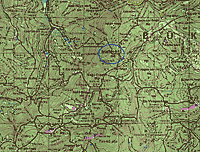
the bus I had time to study my new hiking map of A Bukk the region of hills
behind Eger, and stretching north to the Slovakian border. Bukk means beech,
and there were similarities, but on a much larger scale, to my home ground,
the Chilterns. This map was familiar too, from our hiking maps in Germany. Its
contours, forest and field colours, buildings and roads, would all prove to
be accurate, as were its trail routes marked by colours - K for blue, Z for
green, P for red and S for yellow. Over the next three days I managed to add
those four new words to my vocabulary as I recited them to the colour-blazed
tree trunks. I can even remember the first three now - kekk, zold, piros. If
there were two letters, it was that two routes temporarily took the same track.
A triangle meant the path led to a peak; an upside down U was a cave, and so
on.
On
the bus I had time to study my new hiking map of A Bukk the region of hills
behind Eger, and stretching north to the Slovakian border. Bukk means beech,
and there were similarities, but on a much larger scale, to my home ground,
the Chilterns. This map was familiar too, from our hiking maps in Germany. Its
contours, forest and field colours, buildings and roads, would all prove to
be accurate, as were its trail routes marked by colours - K for blue, Z for
green, P for red and S for yellow. Over the next three days I managed to add
those four new words to my vocabulary as I recited them to the colour-blazed
tree trunks. I can even remember the first three now - kekk, zold, piros. If
there were two letters, it was that two routes temporarily took the same track.
A triangle meant the path led to a peak; an upside down U was a cave, and so
on.Getting off the bus was not so simple. The delightful little old lady who showed me her knee that was hurting her, had got off in one of the villages between. She reminded me of my Tante Hetty, who I always picture as she demonstrated how she had to flap her skirt to cool down on a train. She is a lady who will do and say what she has to, if ever there was one. Her Hungarian counterpart managed to explain to me that she'd been into the clinic in Eger and been given some injections. Old age is not fun was her message, but I can't remember how we spoke.
Hungarian villages seem to be very long, a couple of kilometres of houses in a thin ribbon along the road. I tried to follow the map carefully as we crossed the railway line, and houses began left and right. The valley should go off to the right at a distinct bend, but with my seat companion gone I had no one to check with. Suddenly there was a tap on my shoulder from behind and a woman just a bit older than me gave a warm smile, gestured at the map - tourist? - and, with her solid working woman's arm, she waved me urgently towards the door of the slowing bus - Szilvasvarad. I resolved more than ever I must get into pronouncing this alphabet. It might look like ours, but the sounds are all upside down. Thank goodness for people who can communicate, language or no language.
The bend in the road where I got off fitted perfectly with the map, but it didn't look much like the beginning of a beautiful valley. I went over to the kiosk, found a toilet, and cooled off with a large ice-cream - the time for an ice-cream does come eventually. It seemed to be the right place, but the wide dusty track on the other side of the road was uninteresting. There was a telephone box on the corner, and I'd promised to make a call in the mid afternoon. As it was now past 12.00 - well, what works, works. I set off briskly, and gradually the track filled with small wooden kiosks and restaurants. There were really quite a lot of people relaxing, eating, playing, in the dusty greenery. I decided to go for my hill, feeling happy with my boots and rucksack and a steady pace that rapidly took me out of the lowland rabble and into the refreshing green of woods. Streams and trout pools ran down, and splashed over the rocks. The steep sides of the valley began to close in, and it became cooler and shadier, filled with the dense smells and sounds of the waterside weeds where the flies buzz. There was a wide side track, marked as a cycle route coming down a valley from the left. The steam train, which I'd sort of heard in some rail yards further down, suddenly appeared, loaded with children in its open carriage, quite high above me. I cut across a picnic area, and the station halt. If anything the valley seemed even busier now. Shouting children from the train, and long groups of children walking in twos and threes, swinging plastic bags, squeezing past one another, or dragging behind and complaining to their teacher. This was class expedition day and I'd found one of the favourite destinations.
It was the younger teacher I decided to ask. The children were milling around excitedly, and there were a lot of them for the small apron of dusty ground in front of the cave. Most of the teachers of the various school parties I had passed on the way up had looked tired. Like their English counterparts, they seemed to take the opportunity to chat together, rather than with the children. They had odd bags too, a plastic shopping bag, or even a brown leather attaché case, which might I suppose have held some sandwiches, plasters, headache pills, whatever else you need on the school trip up a well trodden but beautiful valley, with its customary steam train, trout ponds, and woodland museum.
The young teacher had brown hair, and was pretty and plump - surely she would speak some English or German, enough to tell me where the path to Istallos ko was. For the cave was just a cave, possibly quite interesting with fossils and so on, if you could get close to it. The wooden fence posts circled it so there was no continuation behind. Similar posts had guided the slipping, stumbling children's feet up the final 300 metres of eroded zigzag path, and prevented them from straying off into the woods. So where on earth was the path that should have the peak sign for Istallos ko, and not just the cave sign? But the teacher just smiled, shook her head, and started to call a child's name. All were about ten years old, why ask them? After various discussions across their heads, a reluctant boy was dragged forwards - not promising.
I asked, "English? Where is the path up to the peak, Istallos ko?" smiling, hands open, anything to make him feel not so bad about this. More confusing talk between himself and his teacher, then he blurted out in a natural English accent, "It's down there."
"How far down?" I wanted to know pretty exactly. I'd waited patiently in offices all that beautiful morning, and now I wanted to get beyond circling around school trips and well-worn paths to destinations set up by the school board. I was there precisely not to be a teacher. I was trying to work out if the boy was totally clueless with his idea that I had to go right back down to where we had left the main stream, or if my idea of the scale of the map was up the creek, when the man who'd been sitting beside his array of stones, sweets and postcards to sell, came over. He spoke German. Of course he could speak - either from his previous life before 'the change', or from dealing with tourists. And it was simple, the path was marked off to the left about 50 metres below, about at the spot where we'd been grabbing hand rails and branches so we didn't slip. Of course, the side path to the cave had become the main path, and I had missed the green stripe with the triangle painted below, my route to the peak.
Then I really was by myself. It was a different world. The trail was a proper mountain path, just two boots wide. It followed distinctly across the head of a gully, and I scrambled over the branches of a fallen tree to climb out of it, and above the rock wall. The slope above opened out into a wide steep slope that stretched up, with well spaced beech trees casting their light green shade over tall grey trunks, and brown leaves, nut shells and roots criss-crossed the forest floor. I heard rustlings, but I set my mind to enjoying these sounds of the woods and its small creatures, and not jumping out of my skin. It's their place; with luck there could be a deer, and a rustle under the leaves or in the undergrowth over on the left - it's probably a mouse, or a bird scratching around. Wild boar? Too smart to bump into me, I hope. In woods, I feel an interloper. The trees have allowed me in, will they allow me through, and out, to the place on the map I want to be? They have their own way of shaping the landscape, and have fooled me before.
Trees with markers, a good view between them, but only a very faint path. If I missed out one green stripe, and went on too far, I couldn't be sure of finding my way back. It was a good climb - steady rhythm, joy at the arching trees above me, and the beams of light broken by the delicate green leaves. Exhilaration as marker after marker appeared before me. I know this. I can do this. Up to where there should be a path joining - would it be there? Looking back down, conscious of how alone I was, checking the shape of the slope as it darkened towards the fir trees of the gully below. I kept my finger firmly on the map.
There were several path junctions, and the different colours helped. The blighters are the unmarked ones, the ones used by the foresters and hunters, that have become more distinct than a little used hiking trail, and seduce you with their purposeful sense of direction; just as bad are the paths leading off that may be just a deer trail, and not a path at all. They need to be counted, or discounted, to make sure you don't miss the single sign that tells you where you are, even if it's overhung with brambles. But how about getting to the top? The top was my goal and the map didn't show clearly a path to it. One marked route seemed to go round past the back, so would there be a right turn upwards? To my right indeed the ground sloped up more abruptly, stonily, giving the impression of a stronghold that might have been used in centuries previously. The hill felt familiar, like in the Pfalzerwald or Mittelgebirge of Germany - steep wooded slopes, fairy tale valleys with water rushing over stones and into pools, but, at the top, crags and rough ground, with trees more spaced out and smaller. I counted the turns, and the path suddenly made a turn up onto another level. It was something of a T junction, and the path above was wider, leading to a point where I could see through the trees. The wooded hills and valleys swept on for miles, and I was high and alone on my little path. A deer crashed through the undergrowth - not so alone. I let the breath I was gripping out slowly, and went back to the junction marker. Two more turns and I found a single peak marker up to the right.
The path went straight up, very rough, with large stones and branches strewn across it by the rain gullies. The signs gave out. Oh no. I'd met this before too. It's a South African speciality in the Drakensberg. Where the paths are well trodden the markers are there for all to see. Go a little more adventurously, where you really need them, and no-one bothers with the paint pot any more. I guess you're meant to be an expert if you're not actually a novice. So I called up my expertise, back tracked and cautiously tried out the left-hand fork instead. I knew I must be near the top, as there weren't so may trees above me. Not the time to give up. I pushed up hopefully through a thick stand of fir, and was suddenly wading through bushes and rosebay willow herb, dazzled by the bright sunlight glazing the broad expanse of meadow in front of me. Summer heat, flies and mosquitoes buzzing, grass tickled my legs.
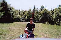 At
the eastern end stood a tall wooden cross, quite new and reassuring in its certainty
that this was the top. First things first - I took out my camera, balanced it
on a small stone pillar (marking what?) in the middle of the meadow, and took
a photo of myself with rucksack, Sigg bottle, etc. in front of the cross. I
had done it - so long as I didn't miss the turns down.
At
the eastern end stood a tall wooden cross, quite new and reassuring in its certainty
that this was the top. First things first - I took out my camera, balanced it
on a small stone pillar (marking what?) in the middle of the meadow, and took
a photo of myself with rucksack, Sigg bottle, etc. in front of the cross. I
had done it - so long as I didn't miss the turns down.There was of course no view, not with all the trees that grew so thickly round the edge of the clearing. Now, it would have been really nice to have someone to enjoy it with, so I did some mental telephoning, "I'm here. It's brilliant, all 959 metres of it, the highest in the Bukk hills, and the second or so in Hungary. I've done it myself." Which is all pretty crazy, because as height goes, it's nothing - well, almost a Munro, about like Snowdon, but being further south it's tame in comparison. No, it was my deep well of attempts, and failures, to achieve heights and destinations, and falling back in the fear that it was 'too big for me' that I was looking out of. The view was terrific.
I bounce down the hill until I am standing on a corner and looking over a different valley and can see no marker. Too fast. Suddenly all the trees are grey and the same. The ground goes this way and that, full of debris and stones, and feels hostile. Should I go straight down? It would likely get worse, and I could be 90 degrees out and in the wrong valley, and tens of kilometres from Svilvaszvarad and the bus home. I'm not even sure which way I've come. Breathe out steadily and pace back cautiously, and of course I'm not that far off route. It's the same old corner fooled me again. But it would be stupid to twist an ankle up here alone.
From here on it's OK. I'm back to a thoroughfare and the lovely colours on trees, not just a washed out triangle. I'm back down my broad beech wood slopes, across the neck of the gully, and in amongst the school parties. While the kids cling to the railings as their teachers with briefcases and bags tell them firmly to stay in line down the steep zigzag, I skip down from rock to rock, hoping I won't make a fool of myself by skidding, but quite sure I'm not going to behave myself in a school queue. I left that sort of responsibility behind 5 days before.
"Excuse me. Sorry." I call. It's not really wide enough to get past easily. And if they speak to me I just say 'Anglia' or 'English, bye bye' and that explains this middle-aged woman in shorts and rucksack well enough. Once or twice I try 'Deutsch?' if the path is broader and I have time for a word. But I want to get back to the bus and Eger, and make a phone call home.
That evening I followed Istvan's advice and tried out the Bayrischer Hof - why go for a German name in Hungary? Well the links are there across the south, and Krautrouladen and Bauchspeck, pepped up with paprika sauce, brought back good taste memories. Even though, an hour and twenty minutes later, I understood the waiter's concerned advice against choosing Krautsalad along with Krautrouladen, I think I enjoyed it more than the English couple, also of 'post-children' age, who were touring from their home near Cahors. It wasn't Franglais style.
Istvan and Erzsebet (popular names in Hungary) had invited me for a glass of wine back 'home'. We sat around their pine dining table with a jug of sweetish red, very drinkable, and I got out my family photos. They worked a treat for reassuring them I was fairly normal, despite travelling alone. We discussed England and Hungary, families and homes, water polo and schools, and teaching and learning English.
"Our children are doing exams, exams, exams now. There's so much pressure. It wasn't like that for us. We had time to grow up," said Erzsebet. I could only agree, it's happening in England too.
They directed me to the wine labels I should look for the next day, as I wanted to visit Eger's famous wine valley, although I didn't understand how it could be just 20 minutes from the town centre. And they encouraged me to visit the Lyceum, a landmark on my secondary agenda, to look at teaching possibilities in Hungary.
"Eger is a very important centre for education in the region," said Istvan. There are lots of schools here, and the children travel in from the surrounding areas. The Lyceum used to be for teacher training, but now it's growing into more of a university." That sounded really interesting; it would be great to teach beyond 16-19 again, with all their growing up problems. So I determined to plan it in, and not give up half way. Eger was proving to be a very liveable sort of town.