2.17 Shady Places
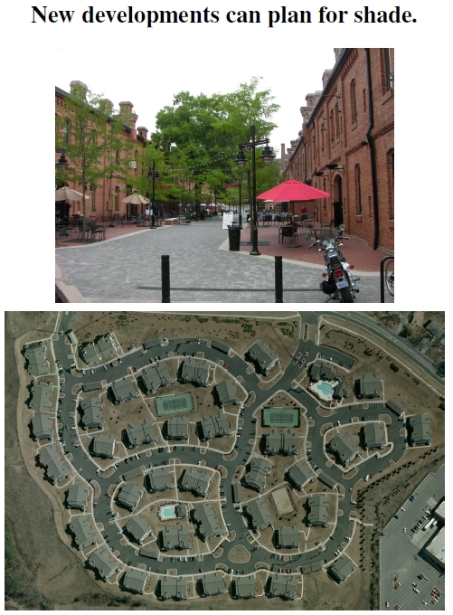
Figure 2.17: At top, outside seating in a small urban canyon known as Brightleaf Square. Trees between the buildings intercept radiant energy between high thermal mass surfaces (compare Figure 2.8 with no interception), as well as provide shade and comfort to restaurant patrons. At bottom, a relatively new gated development arising from warehouse land along Broad Street in Durham, North Carolina, photographed from above in 2005 (courtesy Duane Therriault of City of Durham GIS). Note the spots along the subdivision roads reserved for shade trees.
In the discussion of the urban heat island effect, I showed the results of Figure 2.8, indicating that the “urban canyon” explained much of the phenomenon. A photo shown there had two tall buildings with nothing between them but air, and thermal radiation emanating back and forth from one building and absorbed by the other and the street below. The top photo in Figure 2.17 shows how well-placed trees can intercept the radiation bouncing from impervious surface to impervious surface. Slightly lower albedo paving forms portions of the walkway, helping reduce temperatures by reflecting more light. Besides trees, umbrellas also provide convenient shade and have an important role in urban environments. Though the umbrellas are, technically, impervious surfaces, they keep the sun off more thermally massive impervious surfaces that contribute to heat islands. The umbrellas heat up, but much like the leaves on a tree, quickly transfer their heat to the surrounding air. The pavement the umbrellas shade, however, would hold its heat much longer, on into the evening.
Of course, designers of this commercial area had people’s comfort foremost in mind rather than optimal traffic flow and maximized building volume. They likely weren’t thinking of the public good of reducing the urban heat island: These restaurants need an atmosphere designed for comfort and relaxation, encouraging pleasing social interactions and higher revenues. Later (Figure 5.9) I show that vegetation enhances social activities in public housing, just as it does at these restaurants. Vegetation also correlates with wealth (Figure 6.13), just as it does at these restaurants. Furthermore, it’s a fact that cities keep growing along with the human population (see Figure 1.1). Growing a city means transforming forests and farmland into housing developments and amenities, and, by definition, that means the loss of trees. Yet growth need not mean losing the quality of life that comes from living amidst nature, and this private-sector example, if demanded by citizens, could be replicated for the greater social good.
The bottom photo displays a relatively new development from 2001, arising from barren warehouse land previously stripped of trees. Arguably, the high density doesn’t help recovery by nature, but at least no trees were harmed in the most recent land-use change. This development has no big trees today, like many others that are mass-graded or built on former agricultural fields or industrial land. Yet, to the developer’s credit, it was designed and constructed for future trees that will shade the streets and buildings. Each semicircular unpaved location along the roads and parking spots accommodates a small tree, and, someday, those trees will shade their surrounding impervious surfaces. This development also reflects, perhaps, the underlying reason for the high-income, low-canopy point in Figure 6.13 and provides a perfect example of subdivision age partly predicting the amount of vegetation in a neighborhood.[55]
—————————
[55]Mennis (2006) discusses subdivision age as a factor predicting vegetation.

In the second paragraph, do you mean “slightly-higher-albedo,” which would mean higher reflectivity and thus lower heat absorption and lower temperatures?
Indeed I do. Thanks!