2. 4 UHI Storms
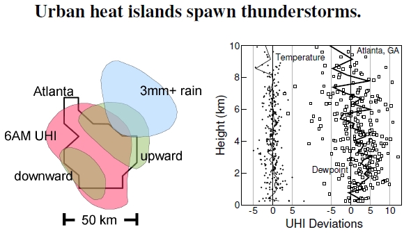
 Figure 2.4: The left image depicts an urban heat island over Atlanta, Georgia, on July 30, 1996 at 6:00 AM. Fifteen minutes later, downward and upward air flows developed from the atmospheric instability and generated a thunderstorm lasting from 6:30 to 6:45 AM, with the indicated rainfall pattern (after Bornstein and Lin 2000). The plot at right, measured on 1996–2000 Atlanta summer days deemed ripe for UHI-induced weather, shows atmospheric temperature and dewpoint differences versus height in the atmosphere between thunderstorm and non-thunderstorm days (after Dixon and Mote 2003; data courtesy of Grady Dixon). Data points are fine-scale measures over narrow pressure values; lines join values averaged over larger ranges. Between 1 km and about 5 km in height, days with thunderstorms have slightly warmer temperatures and much higher dewpoints at lower altitude than at higher altitude. This condition reveals the atmospheric instability.
Urban areas affect the weather. The contour plots shown in Figure 2.4, traced from the originals, caricature a thunderstorm that took place during the 1996 Atlanta Summer Olympics.[10] An urban heat island persisted over nearly the entire urban core in the early morning of July 30, around 6 AM, having a central temperature roughly 2.5C to 4C higher than surrounding areas. This heat island produced a thermal instability leading to two regions of high and low pressure, where air moves upward in one spot and downward in another. Think about a rolling boil taking place in a shallow pan of heated water: Heated water in one spot becomes less dense than nearby spots — maybe due to the vagaries of heating or random shapes and pits in the pan’s bottom — and as that water rises to the surface, slightly cooler and denser water from the surface sinks to take its place. Similarly, air over the city heated by the heat island processes described earlier becomes less dense in various spots. The warm air mass starts to rise, reducing the pressure at that spot, and the surrounding high-pressure air mass pushes more air into that location of rising air. The rising warm air quickly cools in the upper atmosphere, the water vapor that it holds condenses like the drops on a glass of ice water, and suddenly you’ve got a thunderstorm downwind of the heat island.
Examining the weather on all the days during May to September 1996–2000, in Atlanta, the graph at right demonstrates this instability. From the entire set, scientists pulled out 569 days as candidates for UHI-induced thunderstorms because of, in part, low-surface air flows. Over the five years, there were 37 thunderstorms — taking place on 20 separate days — confidently attributed to being spawned by the urban heat island. The study specifically excluded other precipitation events, like those coming in with a weather front, and urban thunderstorms occurring simultaneously with rural thunderstorms.
Indeed, the data showed that these thunderstorms occurred on hot, sticky, calm days when the dewpoint[11] was about 3C higher than usual. In these instances, the UHI could be considered high for the high humidity, and the UHI gives the extra push needed to start the convection of the air mass.[12] In other words, just like in a pan of nearly boiling water, atmospheric convection cells spontaneously initiate and generate thunderstorms. Urban heating turns the heat up just a little bit. In this sense, these results suggest that urban weather isn’t dominated by UHIs; rather, UHIs slightly shift the thunderstorm-or-not balance.
—————————–
[10]Thunderstorms produced by the UHI over Atlanta, Georgia, are discussed by Bornstein and Lin (2000).
[11]Given an air temperature with some humidity level, the dewpoint is the temperature that the air needs to be cooled to for the water to condense out of the air, or in other words, have a relative humidity of 100%.
[12]Dixon and Mote (2003) discuss thunderstorm generation associated with UHIs in Atlanta. Grady Dixon kindly provided the data to produce Figure 2.4. He describes UHI-induced thunderstorm conditions: “When the air is more humid, the UHI is usually less pronounced because the maximum temperature for the day is not as high. However, I found that it is those days when UHI-induced thunderstorms are most likely to occur. The plot showed that greater low-level moisture, in particular, was important for distinguishing between days with or without UHI-induced thunderstorms. However, a cool, humid day will not yield UHI-induced thunderstorms while a warm, humid day likely will.”